I parked at Gargrave and caught the Little White Bus to Hawes and started walking at about 11am. It was cloudy but still warm and dry as I set along the Pennine Way in the northerly direction and started to gain height ascending up Great Shunner Fell. It was a gentle gradient and I made it to the top of the windy summit of Great Shunner Fell (716m).
 |
| The Pennine Way towards Great Shunner Fell |
I carried on north, down to Thwaite, passing a few people on the way down. I avoided the temptation of the cafe in the village and carried on, and along a pretty valley towards Keld. Instead of going into the little village of Keld the PW carries on north along another valley and then up the side of a hill to Tan Hill, the highest pub in England and probably the most remote. I stopped for a half pint of a strong Stout and a bag of scratchings before carrying on along the PW.
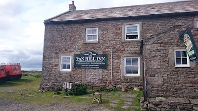 |
| Highest Pub in England |
From here there is little in the way of path for the PW and its just a case of following posts along a boggy and wild moor till you come to a track whichis followed until the turn off at Intake Bridge to cross more Moorland and fields to come to the Gods Bridge and the A66. I was making good progress and thought I would make the most of the light and decent weather before finding somewhere to camp. So it was over the undulating Cotherstone Moor to Blacktone Reservoir.
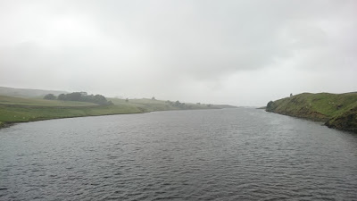 |
| A wet evening, Grassholme Reservoir |
It now was beginning to drizzle so I put on waterproofs and carried on over more farmland to Grassholme Reservoir and then uphill to the next bit of open access land on Crosswaithe Common. It was just after 9pm so I pitched my tent just before it got dark. It was a wet and windy night, but I slept well and woke just before 6am.
 |
| Sunday morning. |
I had breakfast and coffee and then I packed up and started walking again. It was down to the village of Middleton in Teesdale where I was able to get some water from the public conveniences and then it was back along the PW in a north/west direction following the river Tees. It was flat and boring to start with but Low Force and the more impressive High Force waterfalls kept the walk interesting.
 |
| High Force |
I was now in full waterproofs as the weather changed from drizzle to bursts of rain. After following the River Tees for about 8 miles, the PW turns off through another valley and towards the impressive Cauldron Snout where the path becomes a scramble up the side of the waterfalls.
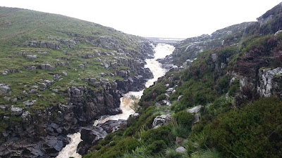 |
| Cauldron Snout |
Its then a long ascent across moorland west towards High Cup Nick. The weather was slowly improving and by the time I came to High Cup Nick it was sunny and I was able to remove the waterproof layers. From here I could see oer the Eden Valley and over towards the Lake District and roughly see my destination of Dufton.
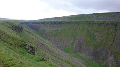 |
| High Cup Nick |
It was then the long decent to Dufton which marked the end of the section of the Pennine Way, but not the end of my walk as I had to walk 3 miles along country lanes to Appleby-in-Westmorland where I caught the train back to Garsdale getting back to my car late sunday afternoon for the drive back home.


