Saturday morning the alarm sounded at 6:30 and I
instantly regretting having drank Guinness and Jagerbombs the night before.
Despite this I managed to get ready and get myself to the station at 7:37 to
catch my first train. After a change at Stafford and Manchester Piccadilly I
was on a train to Edale packed full of other walkers. Having got off the train
at about 10:30, I got a head start on the other walkers and headed in the
direction of the start of the Pennine Way. Up through Edale village I turned
left at the Old Nags Head pub which is the official start of the Pennine Way.
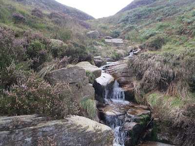
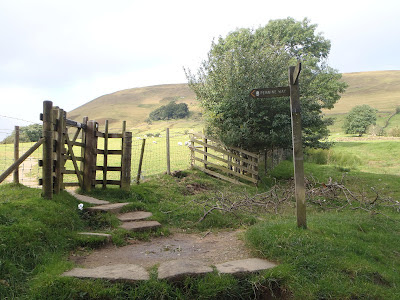 |
| The start in Edale |
The path takes you through the valley to Upper Booth where
you turn up a bridleway up to Jacobs ladder where many mountain bikers struggle
up the hill. After Jacobs ladder the P.W. turns off the bridleway towards
Kinder Low where I passed two guys who looked knackered carrying bouldering
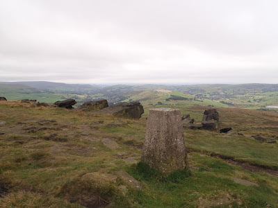
mats up the hill. I reached Kinder Low (633m) which is how I remembered a lunar
like landscape with a flat sandy top with rocks scattered around, of which one
of the rocks has the trig point marking the top. I climbed onto the rock to touch
the trig point and then started again following the P.W. north.
 |
| Trig on Kinder Low |
The P.W. follows the western edge of the Kinder plateau and
I passed a fair few walkers making their way to Kinder Downfall which is a
waterfall (tallest on Kinder apparently). The P.W. then heads in a westerly
direction towards Mill Hill, and goes down hill to a pass where the path
crosses with another and then there’s a small incline to Mill Hill where you
turn right in a northerly direction towards Snake Pass. The P.W. from Mill Hill
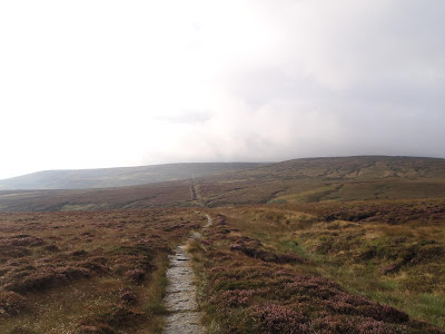
to Snake pass is goes through lovely baron moorland and was one of my favourite
parts of the walk as it felt like I had it to myself. As it was a clear sunny
day I could see moors all around with the northern edge of Kinder Scout to my
right.
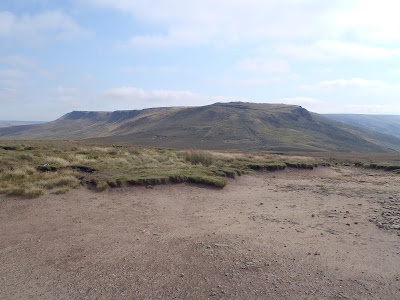 |
| Bleaklow up ahead |
As I passed Featherbed Moss I could hear Snake Pass with the
cars hurtling along the A57 to Manchester or Sheffield. I crossed Snake Pass
and walked for a few hundred metres before sitting down to eat lunch, tucking
into a Pepperami and then a cheesy wrap made the night before. I got up and
carried on up to Bleaklow and passed quite a few walkers which looked like
they’d parked at Snake Pass to get to walk to Bleaklow Head, which is amazing
considering theres not much to see at the top of the hill. I reached the flat top
of Bleaklow Head which is marked with a stake and shoved an Eccles Cake to try
and make the top more exciting before continuing along the P.W. down towards
Torside reservoir.
 |
| The boring top of Bleaklow |
The descent of Bleaklow follows Clough Edge with a drop to
the right into Torside clough, and once down far enough has good views of
Torside reservoir and Black Hill behind. Once down off the hill I walked over
the dam wall of Torside Resevoir and due to the great weather was treated to
brilliant views up Torside reservoir with the rocky sides of Bleaklow to the
right and Crowden to the left.
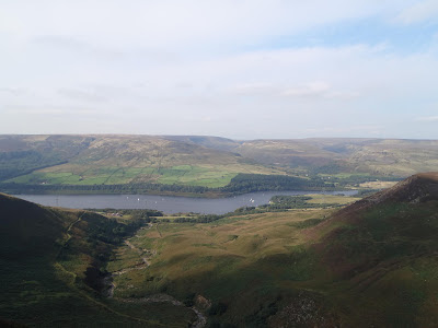 |
| Torside Resevoir from Clough Edge |
At the end of the dam wall I had a brief sit
down to adjust the map and then started walking towards Crowden. I knew I
needed water for the night and I had a decision to make at a crossroads. I could
either walk an extra mile or two to the campsite at Crowden and get drinking
water there, or I could just head straight upto Black Hill and hope I would
find a decent waterfall to grab some water from, which would have the risk of
me not finding anything and having to ration what I’d got or I could face
drinking bad water. I took the risk.
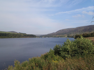 |
| Torside Reservoir |
I made my way up Black Hill which was a decent slog up hill,
but I was distracted as I was on the look out for a water source. I passed a
few small waterfalls but the water didn’t look good (either a funny colour or a
weird foam on top), so I continued up and at a waterfall at Oakenclough brook I
decided it looked alright so I filled my spare bladder.
 |
| The tap |
I continued up the
gradual ascent towards the top of Black Hill which seemed to take ages to get
to the top but eventually got there at about 6:30. Theres not much at the top
of Black Hill apart from a trig point, but there is the sense you are a long
way from any civilization as all you can see is moors all around apart from a
mast a few miles away. It had gotten
cloudy and the wind started to pick up so I got the tent up trying to get the
perfect orientation to which way the wind was blowing.
 |
| Last hundred yards |
I got the tent up and sleeping stuff set up and started on
my dinner, but a couple of minutes into trying to boil some water on the stove,
the gas ran out. So I ended up with lukewarm crunchy cous cous and a tin of
mackerel. The crappy dinner didn’t bother me but the thought of not being able
to make coffee in the morning was the painful part. After dinner I got out the
tent to have a piss and after a check of the tent pegs and after mooching
around a bit I got back into the tent and into the sleeping back. I woke at
about 3:30am and decided to go outside for a piss and to check the pegs due to
the beatings the side of the tent was taking from the wind. I put my boots on
and fought my way through the door, it had changed to claggy on Black Hill and
I could just make out the trig point. I checked the pegs and surprisingly they
we’re fine, so I took a leak watching my piss take off wondering where it would
land. I then hurried back in the tent to get warm again, I woke a few more
times in the night to listen to the abuse my tent was taking, but my reliable
tent Terra Nova Laser Competition did me proud once again.
 |
| The tent on Black Hill before the wind |
Sunday Morning I woke officially about 6:30, I ate
flapjack for breakfast and after going outside to use the toilet I packed all
my things away. I left the tent till last which was difficult as the winds
we’re still strong, but I managed to get it away without loosing it. I started
walking again at about 8:00, it was claggy on Black Hill so I just followed the
stone path north off the hill. As I started to lose elevation I got out of the
clag and could see it was actually rather sunny. I reached Wassenden Head where
the P.W. crosses the A635 where I saw a few early morning cyclists enjoying the
climb or descent depending on which way they we’re going.
 |
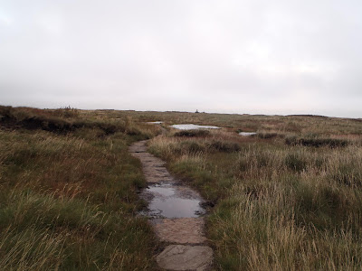
| Pennine Way off Black Hill |
I followed the P.W. to Wassenden Head reservoir and to
Wassenden reservoir, which was a bridleway where I saw a couple of mountain
bikers and I did get a slight feeling of envy. After a some waterfalls the
other side of Wassenden Brook the P.W. left the track and went down and out of
the clough onto the side of the hill, onto some more open moorland where the
path continued to Black Moss reservoir. The P.W. then continued to the A62,
passing over Standedge tunnel (which you wouldn’t know was if it wasn’t for an
info board next to it explaining it was the longest and highest canal tunnel in
Britain).
 |
| Waterfall by Wassenden reservoir |
After crossing the main road I had to stop as one of my
contact lenses was playing up so I used this opportunity to adjust the map and
stuff down an Eccles cake. I continued up the P.W. onto Millstone Edge which
has some good views from the top.
 |
| Millstone Edge |
I carried on along the P.W. and followed it
as it splits off to where it crosses the A640. At this point the weather
started to turn so as the rain started to come down I put on the waterproof
trousers as I already had the waterproof jacket on. It stayed grim as I
followed the P.W. over White Hill and across the bridge over the M62 but as I
came onto the top of Blackstone Edge, the rain stopped and I got some clear
views over Littleborough. The P.W. then went down to the A58 where the path passes
the White House pub, where I sat outside by Blackstone Edge Resevoir to attend
to my sore feet and eat another cheesy tortilla wrap for lunch.
 |
| A wet me by a trig on White Hill |
After feeding and applying vasaline to my heels and changing
socks I continued along the Pennine Way across probably the most boring bit of
walking of the weekend as the P.W. just passed three large reservoirs on a flat
track for 3 miles with just a strong cross wind to make things a slight bit
interesting. After the last reservoir the path passed the end of a hill that
was blocking any view north, and I was able to see a landmark in the distance
which was only a few miles from Hebden Bridge. This landmark was Stoodley Pike
Monument which looked massive even from a far, but it gave me something to aim
for, which made me forget about the blisters on my heels for a while. I
followed the P.W. towards Stoodley Pike and as I got closer the weather started
to get worse so that I could no longer see the white obelisk shape on the hill.
 |
| Stoodley Pike Monument |
I finally reached Stoodley Pike and visibility was terrible
as I had to get within 25 metres to see the monument, the wind was bad so I
walked round it to find some shelter and realized that you could go inside
where there are spiral steps up. It was pitch black up the stairs so I found my
headtorch in my bag and made my way up the spiral stairs to find it took you to
a higher platform outside where I imagine you get some better views when the
weather is better.
 |
| Stoodley Pike Monument closer |
So I made my way back down the stairs and then off the hill
down into Hebden Bridge. I followed the P.W. down to Callis bridge where the
path goes over the Rochdale canal where I left the P.W. and followed the canal
to Hebden Bridge to catch a train home after some fish and chips which I ate on
the platform. I caught the train at 5:52 and after changes at Leeds and
Tamworth I was home at about ten.
Trip Stats
Day 1- 19.5 miles (3760ft ascent)
Day 2- 20.9 miles (1660ft ascent)


