Monday 23 November 2015

1st November 2015- White Rose Ultra


On Saturday evening I arrived at registration at the race Hq in Golcar to the west of Huddersfield and declared that I would do the 60 mile race as opposed to the 100, as I didn't feel motivated enough for it. So after registration I had a quick pint at the Golcar Lily and then slept in the warehouse of the race Hq.
It had been misty in the night for the 100 mile runners, but this had cleared and was turning out a sunny day. We set off with the 30 mile runners at 8am and the first miles ticked away as it does when talking away to other runners. The checkpoints were every 5 miles, with water and some basic snacks, but the water was well needed as it was a very hot day for November. The route followed trail, track and road and after the 15 mile checkpoint went round Pule hill and then down into Marsden along the road. It was then upto the Wessenden reservoirs and upto Wessenden head for the checkpoint. 
Wessenden Reservoir
From the checkpoint it WS along the road for a couple of miles with fantastic views of the valleys below. After another 8 miles it was the end of lap 1 and 30miles in about 5hr20. After a quick coke and a snack it was out again into the heat. It was a more lonely experience as I ticked off the miles meeting more people at checkpoints than runners. This let me focus on the route findings and I soon clocked up the miles and was at the checkpoint halfway round lap 2. I aimed to make it into Wessenden reservoirs before dark so pushed on. I managed to pass a few more runners before I made it to the checkpoint at the end of Wessenden reservoirs when it got dark. 
It was a brief stop at the checkpoint to sort out the headtorch and then continue by torchlight. Some of the markings were a little tricky in the dark but I managed to keep a steady pace and ended up finishing in a respectable time of 11:20.

Tuesday 3 November 2015

16+17th October 2015- The Mamores

On Thursday from Glen Nevis campsite I walked up the valley, through Nevis gorge and after passing Steal falls ascended into the tranquil Valley of Allt Coire Guibhsachen and up onto the col between Carn Mor Dearg and Aanoch Mor. From there ascended the steep hillside and across to the top of Aanoch Beag, for a fantastic 360 view, as it was another sunny day. 
The Mamores from Aanoch Beag
I then backed up onto Aanoch Mor and then down the grassy slopes following the ski tows to the Nevis Centre. It was then a tricky downhill to the bottom, due to no path. But once down it was forest tracks to Fort William to pick up supplies for a two day trip.
Start of Downhill MTB route at Nevis Centre
Thursday night I stayed at the Glen Nevis youth hostel so I could get an early start on Friday. I left at 7:30 in the dark, following the road up Glen Nevis to the start of the path up Mullach Nan Corrien. 
Foggy Glen Nevis
It was a little path through the woods till it came to open hillside and then a good slog uphill to follow the ridge to the top (munro 1). The sun had come out on the ascent and was turning into a hot sunny day.
Top of Mullach Nan Corrien
After taking in the views, I continued along the Mamore ridge to Stob Ban (munro 2). 
Stob Ban
It was then a descent down to a small Loch under Sgorr an lubhair which was followed by a steep ascent to the start of the Devil's Ridge. It started off as a narrow grassy ridge with steep sides and then to a narrow rocky ridge with some fun scrambling.
Devils Ridge to Sgurr a Mhaim
After the ridge it was an ascent upto the summit of Sgurr a Mhaim (munro 3) and more impressive views. After a small rest it was back over the ridge to Sgorr an lubhair.
Devils Ridge to Sgorr an Lubhair
From here there was a small descent and then a bigger ascent onto Am Bodach (munro 4). From Am Bodach it was down and then upto Stob Coire a Chain (munro 5), where I pondered the next difficult ascent up An Gearanach. 
An Gearanach
It was a little ascent and then an easier than expected ascent up the steep southern slope up onto An Garbhanach. But from here it was a scramble across a ridge to the true top on An Gearanach (munro 6). 
On top of An Gearanach
It was back the same way across the scrambly ridge and down to the col below Stob Coire a Chain and then a traverse below the peak to the col below Na Gruagaichean. It was then a long slog upto a flase summit with a cross on.
Na Gruagaichean (false summit)
I briefly basked in the sun before then carrying onto the actual summit of Na Gruagaichean (munro 7) which was a rocky peak where I was surprised to meet someone else enjoying the view. After a good chat I carried on to the highest peak of the Mamores, Binnean Mor (munro 8).
From Binnean Mor
I then descended towards the loch at Coire an Lochain looking for somewhere to camp and settled with a high camp on Sgor Eilde Beag at about 950m. I pitched the tent and ate dinner while the sun went down and the temperature dropped. It was a cold night and not tranquil as the sounds of the rutting stags echoed around.
Sunset looking southish
It was a frosty start, but another beautiful morning. After a pork pie breakfast I pitched the tent and then set off for Sgurr Eilde Mor, which started with an icy ascent up its steep western slope. 
Frosty Morning
It felt hard work, so at the top of Sgurr Eilde Mor (munro 9) I has a quick break. On the way down I passed a couple of walkers who’d had an early start. 
Top of Sgurr Eilde Mor
I went down past the loch I’d passed previously and then down into a valley where I was able to collect some much needed water. It was then up the other side of the valley and a traverse to a small loch below Binnein Beag and a steep rocky slog into the top of it (munro 10) where I was shortly joined by the walkers I’d met half an hour ago.
Binnein Mor from Binnein Beag
It was now about getting down to Glen Nevis to walk back to Fort William. So I picked a line, occasionaly following a path and eventually getting to the bottom of the glen. It was then a long walk athrought the glen, with the highlight being Steall Falls and going through the Nevis Gorge.
Steall Falls
After the gorge the path comes to the car park at the end of the Glen Nevis road, so I briefly followed this until there was an offroad alternative through Nevis forest and a track which went all the way to Fort William where my walk ended. 
Back at Fort William

Monday 19 October 2015

9th-14th October 2015- West Highland Way

Thursday night I caught the last train to Birmingham and then waited for the Megabus at 2:35am. A sleep on the bus and I was in Glasgow about 9amon Friday, from where I caught a train to Milngavie.
Start at Milngavie
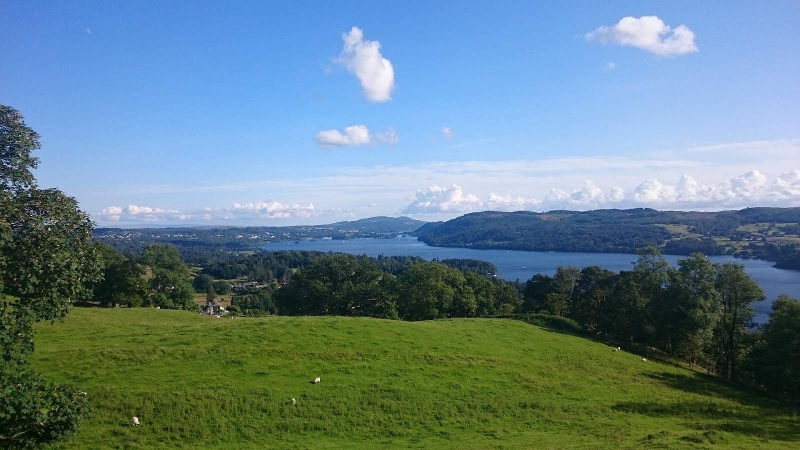
I started the West Highland Way around 10am. A nice start through woodland parks and then into farmland. After Drymen (10mile) it was a walk through undulating forest and then over Conic Hill with views over Loch Lomond. 
View from Conic Hill
Down into Balmaha (20mile) I had a quick pint in a pub, during a quick shower. I then walked a couple of miles to the campsite at Cashel and pitched for the night.
Dinner at the campsite
Saturday. A dry start I set off along the banks of Loch Lomond in search of the Ptarmigan path up Ben Lomond, after first walking past I turned back and found it. 
Rowardennan
It was a long slog up the side of the hill and I eventually reached Ptarmigan summit and then headed up the cloudy top of Ben Lomond. At the top I was greeted by a friendly dog and the cloud cleared for some great views.
Ben Lomond Summit
I returned back down to the WHW and along the path to Rowardennan Lodge where I stopped for coffee before carrying on North. It was rocky round Rob Roy Cave and so was slower going. The path left the loch for a moment to go over a small hill and past a bothy where a German girl was residing for the night. 
Bothy at Doune
After a brief chat I carried on and after many miles along the banks of the loch I reached the head and came to the campsite at Beinglas farm, where I pitched and made the most of the pub. 
Bar at Benglais campsite
Sunday morning was another lovely dry day. The WHW goes through valleys following River Fillan in Strath Fillan to Auchtertyre where I stopped for a coffee and bacon roll. 
Strath Fillan
I carried along the WHW through Tyndrum to Bridge of Orchy with the south face of Beinn Dorain looming over the valley. 
Towards Bridge of Orchy, Beinn Dorain on the right
I got to Bridge of Orchy just before 3 so decided to leg it up Beinn Dorain and Beinn an Dothaidh, bagging two munros before it started to go dark. 
Top of Beinn Dorain
I had a quick pint in the hotel and then headed into the woods for a wild camp, it had been a long day and I settled for the best pitch I could find. It rained in the night and I was often woken by the sounds of the rutting stags. 
Pitch outside Bridge of Orchy
Monday. I packed up the wet tent and carried on the WHW, passing lots of deer on the way. It was another dry clear day and after following the drovers road from Inveroran passed Ba Bridge I detoured up the sides of Meall a Buiridh. 

A stag outside of Bridge of Orchy
I eventually got to the top of an impressive mountain called Meall a Bhuiridh spoiled by the ski lifts to the top, but apart from that the views were magnificent. I then went across a ridge to another munro Creise and then back over to descend following the ski lifts a Glencoe ski station. 
On top of Criese with Meall a Bhuiridh in the background
After a coffee it was a short walk to Kingshouse where I pitched in the wild camping spot by the pub. I enjoyed a nice meal with beer and whisky. 
Kingshouse with Meall a Bhuiridh and Creise behind
The sky was clear and the stars were out as I climbed into my tent. It was a cold night and the deer were in full voice again. 
Frosty morning outside Kingshouse
Tuesday. I woke to a cold frosty morning in Glen Coe and Buichille Etive Mor looked stunning under a crisp blue sky.
Glencoe, Buiachaille Etive Mor left
A few miles in Glen Coe and then up and over Devil's staircase. It was turning out to be a very warm sunny day. 
Over Devils Stiarcase. Mamores behind
After a long descent along forest track I was in Kinlochleven where I stocked up on some food from the co-op before heading back up the hill for the final phase of the WHW. 
Heading out of Kinlochleven
It was through a beautiful Valley, with perfect peace and quiet with only the occasional babble from the stream running through it. 
Ruin in the valley. Stob Ban behind
The walk then goes through some heavily forested woodland and towards Glen Nevis. The last section from Kinlochleven was long and I was glad to get to the campsite in Glen Nevis a few miles from then of the WHW, with Ben Nevis looming overhead.
Ben Nevis, from Glen Nevis
Wednesday morning I woke reasonably early to head up Ben Nevis hoping to beat the crowds, I passed several people on the way up, but then saw no-one as I turned off the mountain track to the valley between the Bens impressive north face and Carn Mor Dearg. It was a dry day, but the cloud came in over Ben Nevis' peak. 
Ben Nevis north face
I crawled up the steep side of Carn Mor Dearg and to the peakbefore heading along the CMD Arete. I enjoyed the easy ridge scramble towards Ben Nevis. 
Me on CMD arete
It was then a steep walk upto the peak which was covered in the cloud with many people on the top. 
Me on Ben Nevis
I then headed back down the mountain track passing at least a hundred people going up. Back at Glen Nevis I followed the WHW to the official end in the centre of Fort William.
End at Fort William

Thursday 13 August 2015

25th August 2015- Lakeland 50

After a good night in the tent it was a relaxed morning, having breakfast and a briefing before being taken by coach to the start of the Lakeland 50 at the Dalemain Estate. After cheering some of the tired looking 100milers pass by, we lined up for the start at midday.
The Start at Dalemain
We started with an easy 4 mile loop round the Dalemain Estate before heading onto the course proper through Pooley Bridge up the first small hill followed by a great run into Howtown where marshalls we're dressed as cowboys. 
Running towards Howtown, Ullswater on the right
It was then into Fusedale and the first real climb. It was a hot day but was nice and cool on the top with a long descent down to Haweswater.
Mardale Head
It was along the side of the Lake to the checkpoint at Mardale Head before the next big climb up Gatescarf pass and then down to a little Valley. Then a small climb and descent into Kentmere checkpoint. Another uphill over Garburn pass and a good descent into Troutbeck marked I was over halfway.
Lake Windermere, before coming into Ambleside
A small uphill and a good run down through the woods to Ambleside for a well stocked checkpoint with more marshalls in fancy dress. Some food a change of socks and I was away, feeling good. After a going over a small hill it was easy running through Elterwater and then the Langdale Valley.
The Langdale Valley
I was making good time and tried to maintain the effort levels. It was a tough ascent up the next steep hill and then the run along the rocky trail along Blea Moor. The running was then straight forward to the last checkpoint at Tilberthwaite. It was still just light as I ascended the last climb and visibility was good over the hill. Four of us ran the last section together and the last technical descent was followed by an easy run along tarmac track into Coniston, narrowly avoiding getting the headtorch out. I finished in 10 hours 36 minutes well ahead of my 12 hour target, so I was/am very pleased.