Wednesday, 8 January 2014

22nd December 2013- Dunedin 3 Peaks route

I woke tuesday morning (22 Dec) had breakfast then caught the bus a 9:13am and got off at the George St/Duke St interchange (roughly the start of the Dunedin 3 Peaks race in Woodhaugh). I then ran/walked up the street and then took a footpath up which took me to Cannington Rd (Wrong turn) but I carried on up the road to another turn off and started running following the path whic pretty much looped round (another wrong turn) and I followed this up to a sign pointing to the Pineapple track and so followed this uphill and eventually came to the summit of Flagstaff, the first peak.
Dunedin from Flagstaff
The weather was very on off, warm, cold, windy, rainy and fine, very much like England. It was easy following the Swampy ridge track to Swampy summit, littered with meteorological stations, masts etc. After being satisfied I was at the top I followed the track back and turned onto the Leith Saddle track down to the road. I crossed the road and went down a gravel track till I came to the a reservoir where I followed a path into the bush and then backtracked after several, minutes realizing it was incorrect.
Boring Track on Swampy
 I then found the tricky path upto Mount Cargill following through thick bush. I came out of the bush to a wide track and I followed this and came to the summit of the third peak, which also had a big mast on. It was windy up there so followed the path off and the long decent into Normanby. I did about 19 miles in total (approx 3 more than meant to). I then walked 2-3miles back to the hostel.
Top of Mount Cargill

Sunday, 22 December 2013

17/18th December 2013- The Queen Charlotte Track MTB

On tuesday morning at 9am I went to Marlborough Sounds Adventure Company in Picton. I tried out the bike, went through some details and was put on the 10am boat. It was very sunny and got very hot. The boat left the harbour and down Queen Charlotte Sound where a load of dolphins picked up the boats trail.
One of the dolphins following the boat
The boat went to 4 stops before Punga Cove so it was just before 12 when I got off the boat and could start riding. I walked through the Punga Cove resort and then started riding when I got to the Queen Charlotte track (QCT). Starting off going uphill I noticed the advantage of the 27.5inch wheels. The bike was a Scott Scale and had what I thought was a good setup. The climbing flattened out after ascending about 200m and I managed to get a good ride out with great views towards my right to Kenepura Sound.
Kenepura Sound in the background
But after about 4 miles it started ascending again, but this time it was so steep I was conceeded to pushing. After reaching about 400m the track stayed pretty high and was rideable but a little undulating. I hadn't seen a single person yet and enjoyed eating my peanut butter sandwich lunch with the views to myself.
Lunchtime views
The track was good and started to descend going past Blackrock shelter and then a great winding descent to the Portage busy road crossing. I had to slow for the odd walker on the way down, trying not to piss anyone off.
Well timed shot
After eating cookies at the Portage Bay road crossing I continued uphill, which was again very steep so again had to push until it came to its highest point of about 450m and it was all fantastic riding from there with some brilliant singletrack and some great rocky decents and switchbacks.
Portage Bay Below
My arms and hands were tiring from the tricky descents, but it eventually came to an end when the QCT came to another road crossing, where I followed it left down to Mistetoe bay. I finished for the day at about 4pm. There was only about 8 miles left of the QCT, and I was tempted to finish it, if it wasn't for the long road stretch back to Mistetoe Bay and the threat of rain.
2nd from last decent of the day
I was booked to stay in accomodation for six individuals, but as no one else was staying there I had a small shack to myself. I felt spoilt as it consisted of a living room, two bedrooms (one with double bed), a bathroom with shower and a kitchen. I made dinner, read and slept in the double bed.
Slap up meal
After a good sleep I started again about 9am.It stsrted uphill but just about rideable, but my legs were still feeling the effects of the day before. The track levelled off and the singletrack was awesome with some sweeping corners, some rocky bits and boardwalks.
Enjoying the view
The section was brilliant and it seemed a shame when I was back at sea level, but at least I had chance to leave the bike and take a dip in the sea at Davies Bay. As it was again hot and sunny.
Davies Bay (all mine for 1/2 hour)
 After the dip and the chance to call down. I carried on and there was still a couple of miles of good track to enjoy before the QCT ended in Anikiwa. It was only about 11am and with my boat pick up being 4pm, I called The Marlborough Sounds Adventure company and told them I would ride back to Picton along the roads.
Anakiwa (end of the QCT)
The road riding was undulating as it would go over a hill and then back down to the many coves. The cycle from Anakiwa was about 15 miles and I stopped for a coffee and cake when I came past a cafe in one of the coves.
Just before the last decent into Picton
After the many undulations the road went up over the hill at about 200m where it descended into Picton and I gave the bike back at about 12:30.


Saturday, 21 December 2013

14th December 2013- 42 Traverse MTB

Route profile
I emailed Kiwi Mountain Bikes the night before and I checked my emails first thing in the morning and Ric from KMB said I could do it, so I rushed to get ready and get there for 9am. I met Ric checked the bike was okay, signed some papers and when another rider turned up we headed off to pick another two Americans and then to the start point
After a breifing we were off, the more experienced American zoomed off not to be seen again and I left the other two but saw them again after I had a puncture and they waited with me.
Bike front, view behind
After a while I left them behind again and I started to enjoy the ride. The track was a Fwd track with some gravel track, rutted mud and some steep rocky descents and a few stream crossings, where I took my shoes and socks off and carried the bike across.
One of the many stream crossings
The route was in spectacular forestry scenery with views of wooded valleys and volcanoes behind. The ride was great and I started to feel my lack of bike fitness at the end of the 46km route.
42 Traverse, Mt Puapehu in the background
It finished at Owhango, where I had a beer and huge sausage roll in a cafe before Ric picked me up.
Waterfall near the end

Wednesday, 18 December 2013

11-13th December 2013 Tongariro Northern Circuit NZ


Wednesday afternoon. I catch the Nakedbus at 1:30pm from National Park village and ten minutes later I'm in Whakapapa. I start the walk along the lower falls walk and then take the turn off on the Northern Circuit towards Mangatapopo hut.
The start
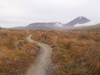
It's a hot day and the sun is out with a few wispy clouds. I pass a few other trampers coming the other way, on the final leg of the same walk but going anti-clockwise. There are some well made paths, boardwalks, steps and where the path is a little bit rough it is well marked by stakes.
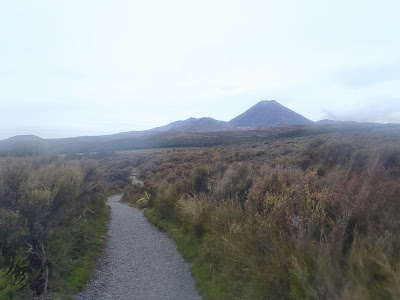
The track, Ngauruhoe on the right
I catch up with a couple of swiss girls and chat with them for a bit and then head off at my own pace. I make it to Mangatapopo hut in just over two hours so I have a long time to kill. The hut is basic but still has gas stoves and water (from the roof) and a seperate toilet block. I hang out and play cards with a very international group consisting off swiss, Israeli, Canadian... before heading to bed.
View from the hut
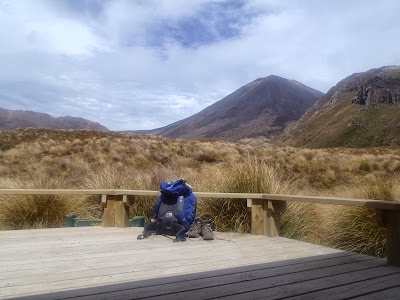
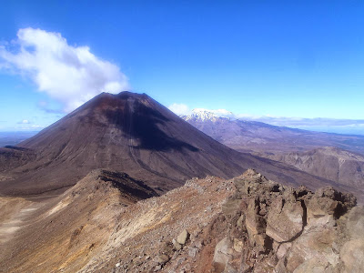
Thursday morning, I wake at about 5am and set off at 5:30. Its light and both the summits mount Ngauruho and Tongariro are clear as there is very little clouds around. I start up the track and start ascending after the soda springs.
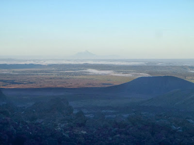
Mount Taranaki in the distance
I pass two guys working the tracks (even earlier start for them) and they point out mount Taranaki (highest mountain on the north island, also sum 100 miles away). I carry on and as I near the crater I see the turn off for Mount Ngaurahoe, so I do.
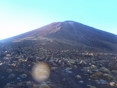
The foot of Mount Doom (Ngaurahoe)
At the foot of the imposing volcano I drop my bag and just take my emergency kit and head upwards. It was a long ascent up a steep incline, with very loose scree. After reaching the summit, I walk to the top and enjoy amazing 360 views and also get an impressive look into the crater.
Ruapehu from the top of Ngaurahoe
I head back down the scree slopes and perfect my ski technique so i'm back down to my pack in no time. I then carry on along the track and as I cross along the flat bottom of South Crater i'm walking past masses of people doing the day walk , the Northern Crossing. After going up past Mangatapopo Saddle I turn off to the summit of Mount Tongariro where eat some Camembert, bread and nuts.
From the top of  Mount Tongariro
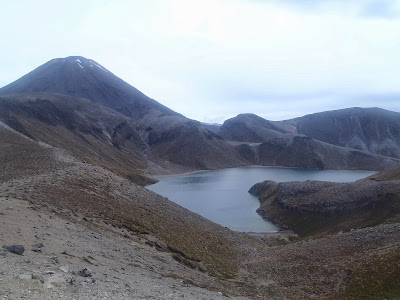
I then continue back along the track passing the Red Crater and Emerald lakes. The track then leaves the Northern Crossing and down Oturere Valley where I don't see anyone until I come to Oturere hut where I share a chat and tea with a French Polynesian man.
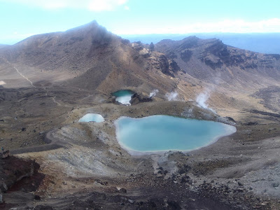
Emerald Lakes
After tea I then had a three hour walk along what felt like a desert and then an uphill and downhill through a forest to come to the Waihohonu Hut, where I was rather worn out. Its still only about 3pm so I read, sit in the sun, walk to an old historic hut and wash in a river to pass the time before eating and going to bed.
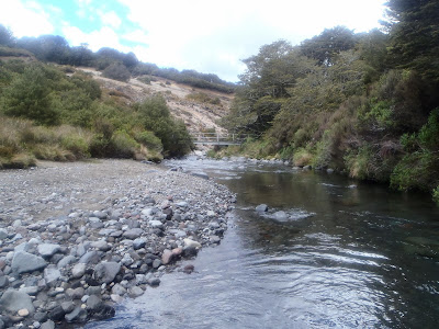
River by Oturere Hut
Friday morning I wake having had loads of sleep. I get off about 7 and head to Whakapapa. I walk along a flatter section through volcanic wasteland with Mount Ngauruhoe on one side an the higher Mount Ruapehu on the other.
Back on track
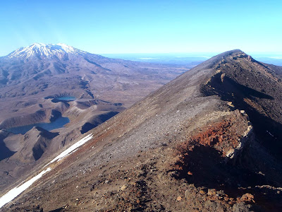
It's another dry day but is cooler as the sun is behind cloud. After a couple of hours I come to Tama Saddle and I take the route off to Tama Lakes, first coming to the lower lake and then after an uphill to the upper lake viewpoint. I realize I have loads of time so I continue along a ridge off the track and up a steep uphill to the top of an unamed peak.
Upper Tama Lake
After getting a good view of the lava flows on the southern slopes of mount ngauruhoe I head back down to the main track. I rejoin the Northern Circuit track and head towards Whakapapa. The track was long and this part had a lot of undulations.
Taranaki Falls
As the track neared its end I passes Taranaki falls and then finished in Whakapapa with a three hour wait for the 3:45 bus back to National Park village.
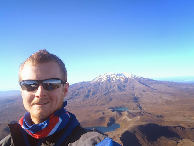
Me on top of Mount Doom


Sunday, 25 August 2013

17/18th August 2013- The Joust 24 Hour


A 24  hour endure set in Holt Castle outside Worcester. The course was a 5 mile circuit which went from the castle through fields adjacent the river Severn, a couple of cow fields with curious cows in. Into a hamlet with a pub which was a checkpoint and water station then through the church grave yard past, another field, through Top Barn activity centre and then a few more fields and back to the castle.
There was a small entry as it was its first year and was limited due to the size of the venue. With 5 teams, 2 pairs and 19 solo runners. The weather stayed reasonably dry despite threatening to pour down, but there was only a couple of light showers.
I started off quite well and soon got into a rhythm with my first few laps taking between 45 and 50 minutes each. I breaked more after and ran slower with my next few taking an hour each. The legs started to ache but we’re never too sore to run. There we’re quite a few gates and stiles which put a bit extra pain in climbing over when landing when jumping over.
The next few laps we’re around 75 minutes each and I had managed to reach nine laps before I would need a headtorch. On the ninth lap I did have to turn down the offer of a pint in the pub from some other solo runners  as I was worried about losing the light without a torch. I did my first night lap in about 95 minutes which totalled ten laps making it 50 miles in about eleven hours which I was happy with so I had a burger as a reward.
I ran my eleventh lap with a girl who was worried about getting lost in the dark, but I had to apologize for slowing her down despite my trying a bit more to run where I hadn’t been doing so before. After a pot noodle and a short break I went out a again on lap twelve. But this is where the boredom really brought my mood down and I saw maybe two runners all lap.
I got back after the twelfth lap and after doing some thinking I decided I wasn’t enjoying it anymore and didn’t see the point in carrying on so I retired after about 14 hours and 60 miles. I went to sleep in my tent and woke up not really regretting stopping despite still having miles in the tank and so packed up and went home.

Sunday, 21 July 2013

13/14th July 2013- Snowdonia

Saturday morning, I parked at Capel Curig and started walking on what was a very sunny and very hot day. After passing Plas-Y-Brenin I headed up the path up Mel Siabod. After my first load of sweating I reached the trig on the summit which had fantastic views of Snowdon, which looked closer than it actually was.
Snowdon from Moel Siabod
After the grassy descent to Pen-y-Gwryd I headed up the Miner's track to the pass between Glyder Fach and Y Foel Goch. At the pass I had some lunch and enjoyed my first good view of Tryfan. After eating I headed onto Glyder Fach where there seemed to be people everywhere. After admirring a stag party getting onto the cantilever stone I reached the summit and headed over to the higher summit (by 5 metres) Glyder Fawr.
Glyder Fach and Glyder Fawr
I reached the summit of Glyder Fawr and after scrambling off the rocky summit I headed down past Llyn Idwal where I got view of my next ascent of Pen yr Ole Wen. After going round Llyn Idwal and down to the road crossing I started the ascent up Pen yr Ole Wen. The ascent is a tough stretch with a lot of height gain in little distance but after some scrambling I made it to the top enjoying a rare breeze on a very hot day.
Pen yr Ole Wen
I carried on and made it to the top of Carnedd Dafydd and after talking to some very tired Welsh 3000er's, I decided to find a place to camp. I settled on a pitch on the grassy side of Cefn Ysgolion Duon. After pitching my tent I cooked my dinner and ate my cous cous with a great view of Tryfan, The Glyders and Snowdon in the background.
Pitch off Carnedd Dafydd
I woke early on Sunday and poked my head out the window to see it was looking like another pleasant morning. But after having breakfast and packing away, the cloud started to cover the top of Carnedd Llewellyn. I walked over to Carnedd Llewellyn which was in cloud cover and after reaching the top I walked to the top of Yr Elen.
Yr Elen
I walked back over the top of Carnedd Llewellyn and then down via Penywaun-wen. As I lost height I came out of the cloud and had it was another hot sunny day. I ascended up Pen yr Helgi Du after a little scramble reached the top and then up Pen Llithrig y Wrach to reah another summit with great views all around.
Pen yr Helgi Du
I walked off the top down to Llyn Cowlyd reservoir and after going a difficult way down due to the bracken and rocky slope, I reached the waterside. I walked round the reservoir and then started trudging up Creigiau Gleison. It seemed a long hot walk but I reached the northern top and then walked over the higher southern peak of Creigiau Gleison. I headed down the western slopes through long grass until reaching the bridleway which I followed back to Capel Curig.
Llyn Cowlyd
Trip Stats
Day 1 14.8miles 7370ft ascent
Day 2  12.8miles 3130ft ascent

Wednesday, 3 July 2013

29th June 2013- Lake District 10 Peaks short

5am start we we're released on the fells. It was light and already looking to be a good day, with just a bit of cloud on the top of Helvellyn. From Swirls car park about a hundred runners and walkers headed up the path to the top of the first peak. After 55 mins at a scout's pace Imade it to the trig at the top, but despite the views I didn't hang around as the running along the ridge and then down off the mountain was brilliant as I passed walkers and less courageous (or idiotic) runners.
Path up Helvellyn
After the first checkpoint (stocked with food and drink), it was the boggy run up the valley to Greenup Edge and then onto peak 2 High Raise. From Higher White Stones I ran down the hillside passing more people walking and running the 10 peaks.
High Raise (High White Stones)
After the run past Rossett Pike and Angle Tarn I walked up onto peak no 3 Bowfell , where there seemed to be 10 peakers everywhere. From Bowfell over Esk Pike (no 4) to the next checkpoint at Esk Hause.It was then onto Great End (no5), Ill Crag (no 6), Broad Crag (no7) and then into the cloud on Scafell Pike (peak no 8). I ran off Scafell Pike and then along the corridor route passing two runners who caught me back up on the way up Great Gable as I started to feel fatigued. At the top of Great Gable (no9) it was claggy, so I picked my bearing and headed off down to the next checkpoint at Beck Head.
Haystacks and Buttermere from the Moses Trod path
After the chekpoint it was a good run along Mosses Trod Path and I looked back and I had lost the two runners who had been with me up until Beckhead. After a long run I made it down to the last checkpoint at Honistor Pass, I turned down hot food but drank a coke with electrolyte mixed in, before heading off on the last leg.
On Dale Head Peak 10
It was a long slog up Dale Head (peak no 10) but after reaching the top it was a a descent into the valley and then along a track to the roads with what felt like  long run/walk to the finish at Keswick. I made it to the end in 9 hour 33 minutes and 22 second,s and was told to my suprise I had finished in 4th position.

Race Stats 30 miles and approx 3000m (9840ft) ascent
LocationLegTotal
P1 - Helvellyn00:51:1600:51:16
FS1 - CP South Thirlmere00:34:5601:26:12
P2 - High Raise01:20:5302:47:05
P3 - Bowfell01:15:5704:03:02
P4 - Esk Pike00:20:0804:23:10
FS2 - Esk Hause00:08:1004:31:20
P5 - Great End00:14:1804:45:38
P6 - Ill Crag00:14:1104:59:49
P7 - Broad Crag00:09:2905:09:18
P8 - Scafell Pike00:12:4805:22:06
P9 - Great Gable01:14:0206:36:08
FS3 - Beckhead----------
FS4 - Honistor YHA-----07:38:08
P10 - Dale Head00:38:0908:16:17
Finish - Race HQ01:17:0509:33:22